Performance Atlas

Announcing the HTML5 Performance Atlas

A fully renovated Performance Atlas for Right of Way is coming at you!

Our shop is humming with intensity! After some fun and thought-provoking design work, we are now deeply engaged in developing the new and better Performance Atlas that many of you have been anticipating. We’ve been pretty immersed in the process and are probably overdue for sharing some updates.

Here are a few…


What’s in the oven?

More map
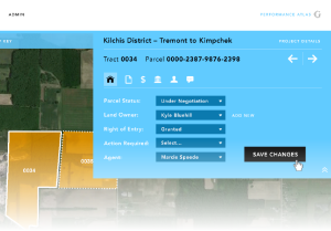
parceldetail_w_fade

Just about every editorial function will now be available from the map view.

  • Update acquisition status
  • Complete tasks
  • Edit landowner data
  • Enter easements
  • Add documents
  • Add permitting information
  • Track expenses
  • Enter stipulations, vesting, and title info
  • Record comments and agent journal entries
  • ....all from the map!

More admin

More control for customizing your Atlas in general and across projects.

  • Setup project-specific settings for items such as tasks, acquisition status values, and additional reference map layers
  • Take advantage of branding and styling settings to personalize and customize your Atlas.
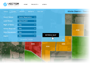
Here's an example of the Fast Filters

More tools

  • “Fast Filters” to gain instant visual feedback about the status of work and performance on projects.
  • Redlining, commenting, and mark up tools
  • Expanded “identify” and “hot feature” feedback tools that work against parcel layers and reference map layers alike.
  • Print reporting with options for high resolution output.

But, wait, there’s More!

Public and Client View modules

Want to offer a subset of functions to collect public feedback at an unsecured / open web address? Want to offer appropriate tools to your customers without letting them get too deep and fudge the system up? These new add-ins will streamline the process!

Responsive design

The new Atlas will be responsive, meaning it will gracefully conform to different devices end-users have for interacting with the tool.

Anything else?

Yes! As some of you know, we work from a “backlog” of features and functions. As we work in the above features, we will move to other capabilities and features. Please keep telling us what you’d love to see! We built this thing for you, guys!


And when’s all this coming out of the oven?

No half-baked software please!  We remain committed to releasing solid, thoroughly tested code. To satisfy our own standards of craftsmanship and make sure you get something that’s ready to run with, we anticipate completing the majority of development work in July and reserving August and early September for integration testing and refinements. Currently, we anticipate releasing the HTML5 version of the Atlas in the third week of September.


What works for you?

You know the drill. We are happy to work in a way that responds to and accommodates your needs and schedules. For many of you, the Atlas is a business critical tool and integrating a major new version must be done with planning and care. Do you have a big project that would benefit from an earlier delivery? Do you need key customizations in place for scheduled work? Do you prefer to delay implementation of the new version for certain reasons?

Let’s talk. We’ll work with you to plan things out in a way that meets your needs.


Our location intelligence quarterly update

Is it already July?

Usually, by this time of year, things slow down a bit, as many organizations’ fiscal years have come to a close. But not this year. This year we continue to be busy well into the summer!

We have a lot going on;

  • Bryce and Tim just returned from Texas, where they met with a new client in the energy sector to discuss configuring our Performance Atlas to meet their needs. The requirements and refinement process will take up the next few weeks before we begin development. We’ll be sure to post more on that as the project proceeds.
  • we’re continuing to working with the City of Portland’s Public School Administration to develop a GIS platform in order to extend location intelligence across business lines, with the initial focus on mapping out safe walking and biking routes to each of their 64 elementary and middle schools. You can read about our adventures in testing, as well as our two part series on developing a GIS-based methodology for Safe Routes to School route finding. Part 1Part 2.
  • we’re wrapping up a consulting project with the folks at Hennepin County, Minnesota where we made use of the brand-new URISA GIS Maturity Capability Model,
  • our two-year project with Seattle City Light to provide Strategic planning and ongoing location intelligence support services is moving along nicely,
  • we’ve wrapped up Phase 1 of configuring our Performance Atlas web application to provide the Etisalat team with a hosted solution that will increase their location intelligence related to performance across sales, marketing and facility planning business lines. We anticipate work on Phase 2 will start up sometime this summer.
  • we’re kicking off a project with Oregon’s Department of Fish and Wildlife to bring the popular hunting and shooting ranges map to mobile devices,
  • back in the Spring, we configured a web application to provide a client with a hosted location intelligence solution providing web access to college campus, floor-by-floor, viewing and updating of facility conditions and assets. We are now improving that application so that our client can make it available to colleges throughout the country.
  • and of course, we continue to provide hosting services to many happy clients!

Just because we have a lot going on doesn’t mean that we’re too busy to talk to you. If you are in need of some GIS consulting, or need a web application for your GIS data, or need a home for your GIS data – or just want to talk – please don’t hesitate to contact us. We’re here!

An update on what's going on around here

Happy Spring!
I know, I know… it’s been Spring for almost a week now, but we’ve been really busy!

We have a lot going on;

  • we’re working with the City of Portland’s Public School Administration to develop a GIS platform in order to extend location intelligence across business lines, with the initial focus on mapping out safe walking and biking routes to each of their 64 elementary and middle schools,
  • we’re helping the Idaho Department of Transportation evaluate the best software for their specific needs,
  • we just kicked off a two-year project with Seattle City Light to provide Strategic planning and ongoing support services in order to fully integrate location intelligence capabilities into the workflows, analysis, and reporting needs of this major electrical utility serving Seattle,
  • we’re in the process of configuring our Performance Atlas web application to meet the needs of Etisalat, one of the world’s largest telecommunications companies; when we’re finished, we will have provided the Etisalat team with a hosted solution that will increase their location intelligence related to performance across sales, marketing and facility planning business lines,
  • we’ve almost wrapped up a project to provide Pike Energy with location intelligence capabilities integrating centrally-managed data, web-tools for project planning and management, and mobile data collection in disconnected scenarios,
  • we just wrapped up a project with Oregon’s Department of Fish and Wildlife to assess the best way to bring the popular hunting and shooting ranges map to mobile devices,
  • we also just wrapped up a project where we configured a web application to provide a client with a hosted solution providing web access to college campus, floor-by-floor, viewing and updating of facility conditions and assets,
  • and of course, we continue to provide hosting services to many happy clients!

Just because we have a lot going on doesn’t mean that we’re too busy to talk to you. If you are in need of some GIS consulting, or need a web application for your GIS data, or need a home for your GIS data – or just want to talk – please don’t hesitate to contact us. We’re here!