"Cloud-Based GIS Setup"

Announcing the HTML5 Performance Atlas

A fully renovated Performance Atlas for Right of Way is coming at you!

Our shop is humming with intensity! After some fun and thought-provoking design work, we are now deeply engaged in developing the new and better Performance Atlas that many of you have been anticipating. We’ve been pretty immersed in the process and are probably overdue for sharing some updates.

Here are a few…


What’s in the oven?

More map
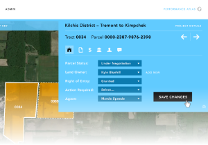
parceldetail_w_fade

Just about every editorial function will now be available from the map view.

  • Update acquisition status
  • Complete tasks
  • Edit landowner data
  • Enter easements
  • Add documents
  • Add permitting information
  • Track expenses
  • Enter stipulations, vesting, and title info
  • Record comments and agent journal entries
  • ....all from the map!

More admin

More control for customizing your Atlas in general and across projects.

  • Setup project-specific settings for items such as tasks, acquisition status values, and additional reference map layers
  • Take advantage of branding and styling settings to personalize and customize your Atlas.
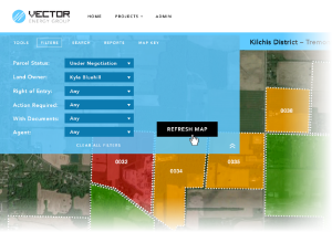
Here's an example of the Fast Filters

More tools

  • “Fast Filters” to gain instant visual feedback about the status of work and performance on projects.
  • Redlining, commenting, and mark up tools
  • Expanded “identify” and “hot feature” feedback tools that work against parcel layers and reference map layers alike.
  • Print reporting with options for high resolution output.

But, wait, there’s More!

Public and Client View modules

Want to offer a subset of functions to collect public feedback at an unsecured / open web address? Want to offer appropriate tools to your customers without letting them get too deep and fudge the system up? These new add-ins will streamline the process!

Responsive design

The new Atlas will be responsive, meaning it will gracefully conform to different devices end-users have for interacting with the tool.

Anything else?

Yes! As some of you know, we work from a “backlog” of features and functions. As we work in the above features, we will move to other capabilities and features. Please keep telling us what you’d love to see! We built this thing for you, guys!


And when’s all this coming out of the oven?

No half-baked software please!  We remain committed to releasing solid, thoroughly tested code. To satisfy our own standards of craftsmanship and make sure you get something that’s ready to run with, we anticipate completing the majority of development work in July and reserving August and early September for integration testing and refinements. Currently, we anticipate releasing the HTML5 version of the Atlas in the third week of September.


What works for you?

You know the drill. We are happy to work in a way that responds to and accommodates your needs and schedules. For many of you, the Atlas is a business critical tool and integrating a major new version must be done with planning and care. Do you have a big project that would benefit from an earlier delivery? Do you need key customizations in place for scheduled work? Do you prefer to delay implementation of the new version for certain reasons?

Let’s talk. We’ll work with you to plan things out in a way that meets your needs.


GIS Hosting for CB&I

Client:  CB&I
CB&I is a global energy infrastructure company with approximately 50,000 employees, working from more than 30 countries.  Growth in demand for GIS services from globally distributed customer groups presented the CB&I GIS and IT teams with a variety of challenges.  These challenges led them to seek assistance from the Gartrell Group to design, implement, and host specialized GIS infrastructure that would offer internal GIS staff, partners, and end users an improved level of service.

Goal: Establish high-performance production GIS infrastructure to support internal and external customers of this globally distributed, Fortune 500 company. 

Services Provided:The Gartrell Group collaborated with CB&I GIS and IT personnel to design, and then implement a high availability (HA), multi-tiered enterprise GIS platform.  The platform includes both data, and application tiers. It supports distributed/ remote editing teams, synchronization with corporate data systems, and integration of mobile data collection, all while conforming to CB&I’s IT security architecture and policy.

The hosted environment has been in production for over five years. The Gartrell Group has provided ongoing enterprise support services which include 24×7×365 system monitoring, regular systems analysis, engineering support, architectural planning and upgrade support.

Key Technologies:  GIS Hosting, ESRI ArcGIS Server, ArcSDE, Microsoft SQL Server, Mobile GIS

“You guys have been there for us.  This is one partnership that has really worked out.  We are definitely more effective since we made the transition to have you host our GIS systems.“  – Bill Harvey, Technical Manager, Geospatial & Information Management, CB&I.

Elasticity: A big advantage of putting your GIS in the Cloud

elasticicityBy putting your GIS in our Cloud, you can take advantage of its elasticity. What that means is, you can engage and retire server resources as and when necessary. Short term or occasional needs for geoprocessing, tile cache creation, running massive regressions, etc. can be met by spinning up and using a server resource for a defined period. You get the resource you need when you need it, but don’t pay for an otherwise underutilized resource during periods of low or no demand.
We work with all of our customers to plan for upcoming and potential needs. As a Gartrell Group customer, you’ll be in a good position to quickly add server resources as demand requires. Application servers, database servers, failover web servers, geoprocessing workhorses…they can all be rapidly integrated into your ecosystem of cloud-based resources. This is that “elasticity” of the cloud you’ve heard about. Bring them up, use them when needed, and then put them to bed — optimize your resource utilization so performance is sustained and you’re not paying for what you’re not using.

If you’ve been pondering the benefits of moving your GIS to the Cloud, give us a shout and ponder no more. Our team can get you set up with right-fit resources so you can focus on what you do best!